


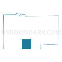
MAY Voting District, Lee County, Illinois
About
Outline

Summary
| Unique Area Identifier | 572575 |
| Name | MAY Voting District |
| County | Lee County |
| State | Illinois |
| Area (square miles) | 35.69 |
| Land Area (square miles) | 35.49 |
| Water Area (square miles) | 0.20 |
| % of Land Area | 99.43 |
| % of Water Area | 0.57 |
| Latitude of the Internal Point | 41.62081930 |
| Longtitude of the Internal Point | -89.33780390 |
Maps

Graphs
Select a template below for downloading or customizing gragh for MAY Voting District, Lee County, Illinois


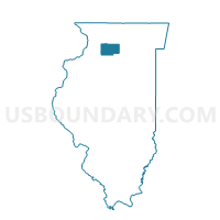
Neighbors
Neighoring Voting District (by Name) Neighboring Voting District on the Map
- AMBOY 3 Voting District, Lee County, IL
- EAST GROVE Voting District, Lee County, IL
- LAMOILLE NO 1 Voting District, Bureau County, IL
- LAMOILLE NO 2 Voting District, Bureau County, IL
- LEE CENTER Voting District, Lee County, IL
- MARION Voting District, Lee County, IL
- OHIO NO 1 Voting District, Bureau County, IL
- SUBLETTE Voting District, Lee County, IL
Top 10 Neighboring County Subdivision (by Population) Neighboring County Subdivision on the Map
- Amboy township, Lee County, IL (3,108)
- La Moille township, Bureau County, IL (1,122)
- Ohio township, Bureau County, IL (823)
- Sublette township, Lee County, IL (776)
- Lee Center township, Lee County, IL (593)
- May township, Lee County, IL (304)
- East Grove township, Lee County, IL (256)
- Marion township, Lee County, IL (232)
Top 10 Neighboring Elementary School District (by Population) Neighboring Elementary School District on the Map
Top 10 Neighboring Secondary School District (by Population) Neighboring Secondary School District on the Map
Top 10 Neighboring Unified School District (by Population) Neighboring Unified School District on the Map
- Amboy Community Unit School District 272, IL (5,261)
- La Moille Community Unit School District 303, IL (1,769)
Top 10 Neighboring State Legislative District Lower Chamber (by Population) Neighboring State Legislative District Lower Chamber on the Map
- State House District 76, IL (105,699)
- State House District 90, IL (103,604)
- State House District 74, IL (100,949)
Top 10 Neighboring State Legislative District Upper Chamber (by Population) Neighboring State Legislative District Upper Chamber on the Map
- State Senate District 38, IL (231,284)
- State Senate District 37, IL (218,476)
- State Senate District 45, IL (209,870)
Top 10 Neighboring 111th Congressional District (by Population) Neighboring 111th Congressional District on the Map
Top 10 Neighboring Census Tract (by Population) Neighboring Census Tract on the Map
- Census Tract 8, Lee County, IL (3,767)
- Census Tract 9647, Bureau County, IL (3,072)
- Census Tract 7, Lee County, IL (2,002)